
NORTH SOUND, DEC. 1: December has arrived and also marks the start of meteorological winter. But wait, doesn’t winter begin on the winter solstice, this year on Dec. 21? Why is there a disparity in the dates when winter is underway?
The shortest day of the year in the Northern Hemisphere – the winter solstice- is based upon astronomical seasons that people have used to mark time for thousands of years.
Astronomical seasons are based on the position of Earth as the planet rotates around the sun. Earth’s 23.5-degree tilt and the sun’s alignment over the equator determine both the winter and summer solstices, along with the spring and fall equinoxes.
Many think that winter is the coldest time of the year and summer as the warmest, with spring and fall being the transition seasons. That is the basis for meteorological seasons. Meteorologists and climatologists around the globe break the seasons into groups of three months based on the annual temperature cycle combined with the calendar.
The coldest months of the year are December, January and February, and hence determine meteorological winter in the Northern Hemisphere. The calendar also makes it much easier to calculate seasonal statistics from monthly weather data versus astronomical seasons – very useful for commerce, agriculture and a variety of other needs.
As if right on time, the coldest weather of the season thus far will unfold the first week of December. High temperatures will have a tough time rising beyond the 40s with lows in the 30s. Frost or freezing fog is quite possible, particularly in places like Arlington and the Cascade foothill valleys. On bridges and overpasses, slippery icy spots are more likely. Have that ice scraper handy for those frosty windshields and windows.
Before the end of the week, a much more active mild weather pattern is anticipated. The first of a parade of Pacific weather systems is slated to spread rain into the North Sound late Thursday, Dec. 4, into Friday. If longer-range weather charts are on track, additional weather systems are expected to follow well into next week.
Mountain Snow
Snow enthusiasts have been anxiously awaiting the arrival of more snow in the mountains. Last year, many resorts had opened by Thanksgiving weekend. Not the case this year.
The more active weather pattern to develop late this week and into next week promises to deliver snow in the mountains. This weekend, snow levels are expected to be around 3,500 feet, meaning healthy amounts of snow for many ski areas. For mountain pass motorists, the change to a cooler, more snowy weather pattern means being prepared for winter driving conditions. The North Cascades highway will likely close for the season soon.
November Rain and Temperatures
November just finished and is usually the year’s wettest month. For much of the month, that reputation held firm. Then, higher pressure aloft built over the Pacific Northwest, resulting in a dry finish to the month along with some sunshine.
Despite what seemed to be a wet month of November, Everett-Paine Field finished close to 3 inches below average with a total of nearly 2 inches of rain. November was the 11th straight month with below-average rainfall. The total through November was about 10 and a third of an inch. The average for the 11 months is close to 28 inches. Rainfall for the whole year is only about 37% of the average.
According to the U.S. Drought Monitor, much of Western Washington, including the North Sound, remains in moderate to severe drought conditions.
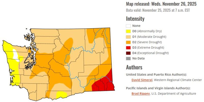
November was also warmer than usual. Paine Field finished the month about 2 and a half degrees warmer than average.
Weather Outlook for December
Longer range weather guidance points to a wet period next week with snow in the mountains. Toward the middle of the month, it is possible that a much cooler weather pattern could develop. This change bears watching at this point. With a La Niña pattern in place heading into this winter, it is not uncommon to have at least one lowland snow event.
For those who desire a White Christmas, the odds of that kind of day for much of the North Sound are low – only about a 5% chance. The last significant White Christmas was in 2008, when many parts of the North Sound had at least 6 inches of snow on the ground for a festive day.
With La Niña in play, cooler weather should unfold heading into winter. Stay tuned!
