
NORTH SOUND, DEC. 15: Mid-December weather has a nasty history in the North Sound. The latest bout of hazardous weather came last week, when warm, heavy rain caused widespread flooding and landslides.
Back in 2006, during this same time period, the Hanukkah Eve Windstorm struck Western Washington and the North Sound. From the evening of Dec. 14 into early Dec. 15, the storm battered through the region with southerly wind gusts up to 100 mph.
Thousands of trees fell across Western Washington, knocking out power to more than 1.8 million people and causing hundreds of millions of dollars in damage. The storm destroyed about 70% of Puget Sound Energy’s infrastructure, and Snohomish County PUD suffered substantial damage to power equipment. Some people did not get their power back until Christmas Day.
The storm resulted in 15 fatalities, four of them directly from the storm, and 11 afterwards from carbon monoxide poisoning. Thanks to the cold and lack of power, some people used barbeques and other heating and cooking elements indoors, causing the tragic post-storm deaths. Hundreds were also poisoned.
Warm rain returns Monday
Another warm, wet storm is expected to dump more rain on Monday, Dec. 15, and Tuesday this week. Many North Sound rivers have receded from their high levels, yet the renewed rain will push rivers back up again.
The Skagit, Skykomish, Snoqualmie, and Snohomish Rivers are expected to rise to moderate flood levels once again on Wednesday, but below the high levels from late last week.
Monitor the latest river and flood conditions on the rivers and lakes page at weather.gov/seattle/. The wet weather will also maintain the threat of more landslides.
High temperatures on Monday will be about 15 degrees above normal. A number of Western Washington locations could potentially reach 60 degrees. The record high at Everett-Paine Field is just 54 degrees, set in 2023, and could easily be broken.
Windy Monday
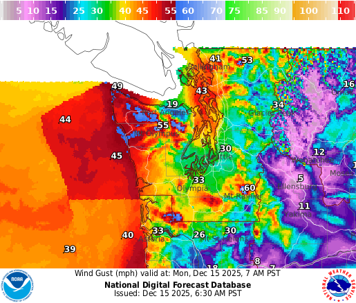
This system will also produce blustery winds later Monday into Monday night. For the North Sound from about Everett northward, gusts are forecast to peak between 30 and 50 mph. Given the soggy soils, these winds will be capable of knocking down trees or limbs. Prepare for the potential of power outages.
If there was a silver lining from the recent seasonably mild weather, heating costs have been lower.
Much cooler weather later this week
A big change in this warm period of rainy weather and the flooding will unfold mid-week. A rather dramatic weather pattern will bring much cooler air from the Gulf of Alaska behind a cold front on Tuesday. Snow levels on Wednesday are forecast to tumble to around 2,500 feet.
Showers the rest of the week will result in a return of snow in the mountains. In fact, up to 2 to 4 feet of new snow is forecast through Thursday, with more anticipated heading into the coming weekend. Motorists with plans to cross Cascade highways should plan on winter weather driving conditions. Per state law, be sure to carry chains in case road conditions require them.
The big change in the weather pattern will also allow rivers to finally fully recede.
Temperatures across the North Sound will be much more seasonable starting Wednesday, only in the mid-40s to near 50, while lows will range from the mid-30s to mid-40s.
This weekend and beyond
Looking ahead to Christmas Day and toward the end of the month, the latest weather outlook reflects cooler and wetter than average conditions. For those wishing for a white Christmas, the mountains will do the trick, with wet weather anticipated for the North Sound.
