
NORTH SOUND, OCT. 22: Moving into the final weekend of October looks to be a wet and windy one for the North Sound.
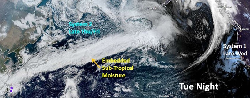
One of the strongest Pacific weather systems of the season so far is forecast to swing onshore Thursday night, Oct. 23 and Friday, Oct. 24. This system will have a source of sub-tropical moisture coming all the way from the western Pacific.
Rain is expected to develop across the North Sound late Thursday and continue well into Friday. This weather system is being driven by the season’s strongest jet stream thus far, with westerly winds of 150 to 200 mph.
Strong southerly winds are anticipated to develop ahead of this weather system Thursday, reaching 25 to 40 mph with gusts up to 50 mph overnight from Whidbey Island and Northern Snohomish County northward to the Canadian border.
Much Needed Rain
North Sound rain amounts by Friday night is expected to range from one to two inches. In the mountains, two to four inches of rain are anticipated with snow above 6,000 feet. Given that rivers and streams have relatively low stream flows at the moment, no river flooding is anticipated.
Yet, North Sound roadways may have local ponding of water, resulting in the potential of hydroplaning. Motorists are advised to slow down and take it easy during this period of significant rainfall.
The rain will help begin to make a dent in this year’s rain deficit. Everett – Paine Field is more than 13 inches of rain behind for the year thus far. The U.S. Drought Monitor continues to show the North Sound and northern half of the Cascades in moderate to extreme drought.
Clogged Storm Drains
The blustery winds will likely knock down a good share of leaves on the region’s trees. Combined with the rain, storm drains are likely to collect and be blocked by leaves, resulting in ponding of water on roadways. Local utilities ask residents to help clear storm drains during this stormy weather.
The Weekend – Falling Mountain Snow Levels
This weather system will continue inland over the weekend, but will leave behind a much cooler atmosphere, resulting in showers. Mountain snow levels are expected to fall to their lowest levels of the season thus far, close to 3,000 feet by Sunday. Snow amounts are forecast to range from 8 to 18 inches of fresh snow. The Stevens Pass Highway will likely get its first accumulating snow on and approaching the pass. Motorists need to be prepared for winter weather driving conditions.
In the lowlands of the North Sound, showers and sunbreaks are anticipated this weekend. Daytime temperatures will rise only into the 50s with lows in the 40s.
Next Week and Beyond
Looking ahead to the weather during the final week of the month, more Pacific weather systems are expected to swing onshore with rain at times. High temperatures will remain rather cool, only in the 50s. At this point, be prepared for wet conditions for Trick-or-Treaters.
The longer-range outlook into early November continues to reflect a cooler and wetter than average period of time. Yes, more typical fall weather has arrived.
